Utilizador final previsto: Professor, formador de professores
Grupo etário: Primário superior; Secundário inferior
Currículo escolar: Ciência
Temas e tópicos: Alterações ambientais; Informação e conhecimento
Duração: 2 x 50 minutes (plus optional extensions).
Tipo de recurso: Experiment, Audio/Video, Presentation, Simulation, Workshop
Palavras-chave: Bathymetric Mapping, Data Interpretation, Model-Based Inquiry Learning, Environmental Visualization, Systems Thinking
Línguas: Inglês
Descrição
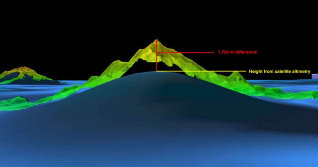
Wet Maps is an educational resource designed for middle school students (grades 6–8) that introduces the principles of bathymetric mapping—measuring and modelling the ocean floor using sonar technology. Through hands-on activities, students simulate multibeam sonar mapping by using sounding rods to gather depth data from a concealed seafloor model. They then analyze and interpret this data to create 2D graphs and a 3D paper model of underwater terrain. The lesson emphasizes the importance of sound over light in underwater exploration and develops key scientific practices such as modeling, data analysis, and system thinking. It incorporates cross-disciplinary learning in Earth Science, technology, and environmental education. The resource encourages critical thinking about oceanographic technologies and how scientists visualize and study submerged landscapes, supporting deeper environmental understanding and technological literacy. Extensions include exploring the history of ocean mapping and modern applications in marine science.
Como utilizar este recurso
To use Wet Maps, begin by introducing students to sonar and ocean mapping using the included NOAA videos. Prepare seafloor model boxes with hidden features and grids, and provide each group with sounding rods, data sheets, and graph templates. Guide students to insert rods through the grid to collect depth data, record measurements, and graph each row using colour to indicate depth. After completing all rows, students cut and assemble their graphs to create a 3D paper model of the seafloor. Conclude with a class discussion on the accuracy and limitations of models, and connect the activity to real-world applications in marine science and sustainability. This resource supports inquiry-based learning, teamwork, and systems thinking, making it ideal for teaching both scientific method and environmental awareness.
Os recursos
Wet Maps – teachers guide PDF:
Resultados de aprendizagem (professores)
- Obter conhecimentos prévios e aprofundar o conhecimento e a compreensão dos conceitos-chave da Cidadania para a Sustentabilidade, desafiando as visões do mundo e os valores estabelecidos.
- Aplicar uma série de ferramentas e quadros adequados para promover a Cidadania para a Sustentabilidade dos estudantes
- Através de actividades de workshops e de comunidades de prática, desenvolver capacidades e agência enquanto educadores e líderes da Cidadania para a Sustentabilidade.
Competências verdes
- Incorporar valores sustentáveis: Valorização da sustentabilidade; promoção da natureza
- Abraçar a complexidade na sustentabilidade: Pensamento sistémico; Pensamento crítico; Enquadramento de problemas
- Perspectivas de futuros sustentáveis: Pensamento exploratório
Creative Commons
Wet Maps is adapted from educational materials provided by NOAA Ocean Exploration. Content includes publicly available resources such as multimedia, activity guides, and fact sheets designed for non-commercial educational use. All rights remain with the original source. No endorsement by NOAA is implied.
ODS